 |
|
WindApplet Usage |
| Caribbean Regional Node | ||
|
|
WindApplet Usage |
| Caribbean Regional Node | ||
Close Window | Information | Data | Software | Sites | Education | Feedback | News
NRT SeaWinds Data Online
Caribbean Regional Mode
We will explain briefly how the applet works.
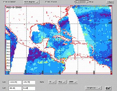
This interface displays Near Real-Time wind data from the SeaWinds sensor on QuikSCAT. The region can be selected interactively or using the text fields on the left. Data can be retrieved in different formats :Both ascending and descending passes can be displayed. Default maps show winds using the typical barb notation in knots. Vector density depends on the value selected in the upper scrollbar. It represents the sampling rate when reading the dataset. The smaller the value, the greater the vector density. A value equals to 1 produces an output where the whole set of vectors are shown. Data can also be gridded to various resolutions. Finally, scalar representation is shown when the field labeled 'Vel Field' is on.
- Graphics - Output goes directly to the applet
- Binary Data - Binary formatted output
- ASCII Data - ASCII formatted output
- GIF File - Output is a GIF file
This applet is based on the TMAPapplet developed by Jonathan Callahan at NOAA/PMEL. Please, send any comments and sugerences that you think can contribute to improve the products to the CoastWatch Caribbean Operations Node Manager. Don't forget to register if you plan to return here. It's easy and free and it allows us to know about our users and provide you with a better service.
 |
Back to main page | USDOC | NOAA | NESDIS | CoastWatch |