|
|
Data Regions |
| Caribbean Regional Node | ||
Information | Data | Software | Sites | Education | Feedback | News
| |
|
Data Regions |
| Caribbean Regional Node | ||
Information | Data | Software | Sites | Education | Feedback | News
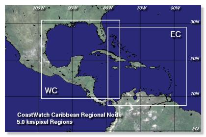
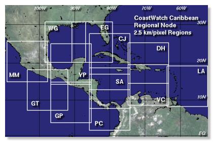
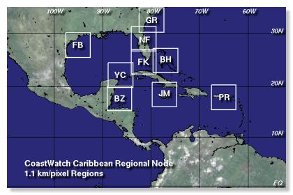
CoastWatch Caribbean satellite data files cover a number of regions from Central Mexico to the Eastern Caribbean. Standard data files are 512 by 512 pixels in size, in either 1.1, 2.5, or 5.0 km/pixel resolutions as shown on the three maps below. Two special "full coverage" files are also available for the entire region: the XX product at 2.5 km/pixel and the XS product at 10.0 km/pixel.
Low Resolution: WC-Western Caribbean Synoptic
EC-Eastern Caribbean Synoptic
Medium Resolution: CJ-Cuba / Jamaica Synoptic
DH-Dominican Republic / Haiti Synoptic
MM-Mazatlan / Mexico Synoptic
GT-Gulf of Tehuantepec Synoptic
GP-Gulf of Papagayo Synoptic
PC-Panama / Western Colombia Synoptic
SA-San Andres Bight Synoptic
VC-Venezuala / Colombia Synoptic
LA-Lesser Antilles Synoptic
WG-Western Gulf of Mexico Synoptic
EG-Eastern Gulf of Mexico Synoptic
YP-Yucatan Peninsula Synoptic
High Resolution: NF-Northern Florida
FK-Florida Keys
BH-Bahamas
PR-Puerto Rico
YC-Yucatan Channel
BZ-Belize
JM-Jamaica
GR-Grays Reef
FB-Flower Garden Banks
 |
Back to main page | USDOC | NOAA | NESDIS | CoastWatch |