 |
|
WindApplet Usage |
| Caribbean Regional Node | ||
Close Window | Information | Data | Software | Sites | Education | Feedback | News
Near-Real Time (NRT) Wind Data Online
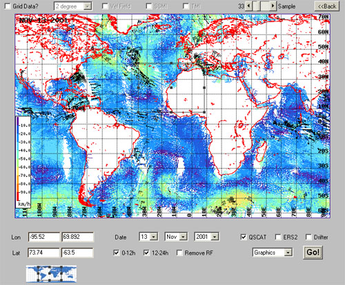
This interface displays near real-time wind data from a variety of sensors. You can click and drag the mouse on either of the displayed maps to select the area of interest. Data can be retrieved in different formats :
- Graphics - Output goes directly to the applet
- Binary Data - Binary formatted output
- ASCII Data - ASCII formatted output
- GIF File - Output is a GIF file
Data can be selected depending on the satellite pass time (in UTC). Default map shows winds using the typical barb notation in knots. The 'Sample' scrollbar controls the sampling rate when reading the dataset. The smaller the value, the greater the data density (and slower the response time). A value equal to 1 produces an output where the entire set is shown. Being the drifter wind data volume low, it is always displayed to full resolution.
To grid data, check on the 'Grid Data?' checkbox and choose the spatial resolution on the list next to it.
Scalar representation is shown when the checkbox labelled 'Vel Field' is checked on.
QuikSCAT data can be rain flagged; these data are displayed in black. If you want to exclude these data from the output, check the 'Remove RF' checkbox.
This applet is based on the TMAPapplet developed by Jonathan Callahan at NOAA/PMEL. Please, send any comments and suggestions you think can contribute to improve the products to the CoastWatch Caribbean Operations Node Manager. Don't forget to register if you plan to return here. It's easy and free and it allows us to know about our users and provide you with a better service.
Disclaimer:
These data have been only subjected to basic quality control or quality assurance procedures. Timely delivery of data and products from this server is not guaranteed. Products are released for limited public use as preliminary data to be used only with appropriate caution.
 |
Back to main page | USDOC | NOAA | NESDIS | CoastWatch |